Dear Readers,
I am experiencing photographic difficulties with my Blogger account. I will not post until the issue is resolved.
Georgia
I am experiencing photographic difficulties with my Blogger account. I will not post until the issue is resolved.
Georgia
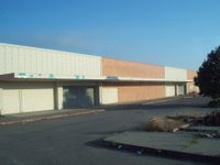
On October 14, we boarded a bus with several dozen people to "re-view Richmond." The bus tour was the culmination of a symposium on regional equity with Richmond as the case study. The one-day symposium was organized by the Department of Geography and the Center for Community Innovation at UC Berkeley as well as the Mid-Atlantic Regional Center for the Humanities at Rutgers-Camden, New Jersey.
The keynote speaker was MacArthur Grantee and photographer Camilo Jose Vergara. Vergara, Shirley Ann Wilson Moore, Donna Graves, Lewis Watts, and Paul Groth (UC Professor) narrated the bus tour. Groth prepared the site list for the bus tour. There are 36 points of interest on the site list. We photographed nine points, six of which are included in this post.
1. World War II Kaiser Shipyard #3, now a National Park Service site.
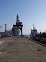

(Notice the the water-level work chambers in the second photograph.)
2. Watermelon truck - Richmond used to host numerous truck farms.

3. Former Ford Motor Company assembly building - note the roof articulation.

(See Kite Aerial Photography for more comprehensive views.)
4. Remnants of Oishi nursery.
5. Remnants of Sakai nursery.


From Paul Groth's notes: The nursery companies were established by Japanese-American families before 1910, and some of the greenhouse structures date back to the 1920s.
6. Abandoned and de-signed Toys-R-Us.
The keynote speaker was MacArthur Grantee and photographer Camilo Jose Vergara. Vergara, Shirley Ann Wilson Moore, Donna Graves, Lewis Watts, and Paul Groth (UC Professor) narrated the bus tour. Groth prepared the site list for the bus tour. There are 36 points of interest on the site list. We photographed nine points, six of which are included in this post.
1. World War II Kaiser Shipyard #3, now a National Park Service site.


(Notice the the water-level work chambers in the second photograph.)
2. Watermelon truck - Richmond used to host numerous truck farms.

3. Former Ford Motor Company assembly building - note the roof articulation.
(See Kite Aerial Photography for more comprehensive views.)
4. Remnants of Oishi nursery.
5. Remnants of Sakai nursery.


From Paul Groth's notes: The nursery companies were established by Japanese-American families before 1910, and some of the greenhouse structures date back to the 1920s.
6. Abandoned and de-signed Toys-R-Us.

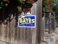
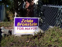
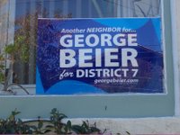
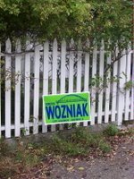
About two weeks ago, we began receiving election literature--in the mailbox, stuffed under the door, attached to the door. There was even a home visit by volunteers. Inspired by the deluge of election literature, I began to look around for signs, literally, that other people were participating in political life. The photographs were taken along Stuart between California and Adeline and within an area bounded by Shattuck, College, Dwight, and Ashby.
Mayors
Measures


Districts

Mayors


Measures


Districts


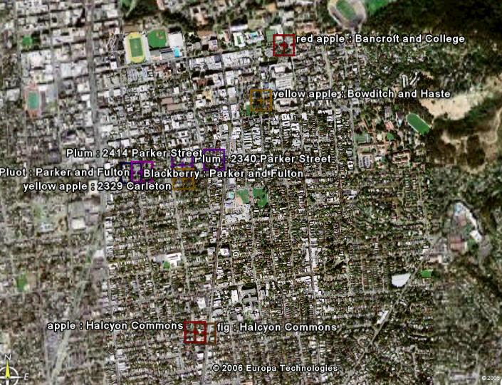
Made with Google Earth, 10/11/06
Here is my first attempt at a local "fallen fruit" map. I have mapped eight sites in Berkeley, three of which are in the public domain: the fig and apple tree at Halcyon Commons, the apple tree at Bowditch and Haste (People's Park), and the apple tree at 2329 Carleton (it is in the sidewalk nature strip). The remaining fruit trees are located on private property but the fruit does fall into and/or hang over the public domain.
The fallen fruit or public fruit concept was developed by Fallen Fruit, an "activist art project" located in Los Angeles. The group encourages the mapping of public fruit locations across the country. Currently, there are four public fruit maps on fallenfruit.org. The site also offers a how-to sheet for mapping public fruit.
I am familiar with several other organizations that focus on fruit. The Big Backyard Project is a "crop-sharing" program that collects surplus fruits and vegetables from yards in the Temescal neighborhood of Oakland, CA. The project is sponsored by Temescal Amity Works. Another local fruit organization is Village Harvest. Village Harvest also collects surplus fruit from yards, but the organization's primary partners are food banks located in the Santa Clara Valley.
Outside the Bay Area, EarthWorks Projects in Boston runs an Urban Orchards Program using several sites throughout the city. Sites include a historic orchard in a city park, an orchard located in a public housing neighborhood, a schoolyard orchard, and an orchard within an urban wild. A list of orchard sites is available online.
For a geographic database of farms, farmers' markets, and CSAs, check out Local Harvest.
Note: The original version of this post first appeared on 10/9/06. This version was made on 10/10/06.

Silver, solar-powered, musical bus at Telegraph and Dwight, 10/8/06
Double-click on the image to read the text on the far left.
In episode 318 of This American Life, a segment about a bad neighbor was accompanied by the song "I Got to Get Away" by Dave Parker.
According to Jay Walljasper, guest editor of Terrain on "The Music of It All,"
Music, more than any other American art form or entertainment industry, truly reflects the rich geographic diversity of our country....Why is a sense of place usually an ingredient in the best music? That’s because great musicians...generally get their start by performing for hometown audiences, where they develop their skills and gain a following.
The sighting of the musical bus, the special issue of Terrain, the airing of the neighbor segment on public radio as well as a posting on Walking Berkeley about entertainment fliers sparked an internet search for songs related to neighbor and neighborhood. Here are three titles.
Say a prayer (for my neighbor)* by Saratoga Sound Ltd.
Everybody has a neighbor* by Stereo Agency
Won't you be my neighbor?
recorded by separately by Roberta Flack and Jon Secada on the Mister Roger's album
lyrics by Fred M. Rogers
It's a beautiful day in this neighborhood,
A beautiful day for a neighbor.
Would you be mine?
Could you be mine?...
It's a neighborly day in this beauty wood,
A neighborly day for a beauty.
Would you be mine?
Could you be mine?...
I've always wanted to have a neighbor just like you.
I've always wanted to live in a neighborhood with you.
So, let's make the most of this beautiful day.
Since we're together we might as well say:
Would you be mine?
Could you be mine?
Won't you be my neighbor?
Won't you please,
Won't you please?
Please won't you be my neighbor?
*Free download at Amazon.com.

Prince and Wheeler Streets, Berkeley, CA
Fall is the transition season between summer and winter. It's a time of harvest, ritual, and thanksgiving. Most of all, it is full of changes and we often develop a sense of decline with shorter days and colder or wetter weather. The photographs in this post were taken at various points during the past year. Only one was taken as a sign of fall (the yellowing locust above), but they all feel like the season that's upon us.

Abandoned grocery store (A&P?), Bergen Mall, NJ

Abandoned barn, photographed while taking the wrong road to Livermore
Note: This post was edited on Jan. 20, 2007. Hotlinked image(s) were removed. Follow the link(s) to the image location(s).
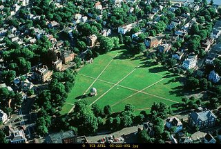
Salem Common, MA (UC Berkeley, Arch. Visual Resources Library)
From the town common of Puritan New England towns to Berkeley's neighborhood commons designed by Karl Linn in the 1990s, the idea of "commons" has been practiced in our town and city landscapes. This post considers points of view and the practice of the commons.
Let's first consider the "tragedy of the commons," famously, though erroneously defined, by Garret Hardin in 1968. According to Peluso (2006), the tragedy of the commons is really "the tragedy of open access," or non-exclusive access and use. Hardin proposed (state) centralized resource management or privatization. Critiques of Hardin's formulation redefine a common as a group of people directly involved in decision-making about a resource or landscape (see Elinor Ostrom (1990) Governing the Commons: The Evolution of Institutions for Collective Action).
The New England common was based on the idea of commons brought over from England. In the context of New England, this town space was used as pasture and for militia training among other things. The town common was also built in other cities like Philadelphia's Rittenhouse Square (originally Southwest Square) and Franklin Square (originally Northeast Square) were used for pasture and night soil dumping. Writing in 1944, Walter Firey argues that the preservation of the Boston Common in the high-value market of downtown Boston derives from the sacredness of the landscape, "its representation in peoples' minds as a symbol for collective sentiments."
Writing fifty years later, Brian Donahue (1999, Reclaiming the Commons) concurs with Firey adding the idea of actual engagement with the land as the only way to know, care, and keep our landscapes. Donahue writes,
To have a real commons was something more than enjoying a park, in other words, more than tossing a frisbee on the town green....We proposed to employ foresters and farmers, but they were to answer to a local board of citizens, the Conservation Commission. They were to employ local young people, and they were to produce food and firewood for local consumption. This struck me as constituting a modern commons, in the full sense of the word.
In a manifesto-article titled Reclaiming the Sacred Commons (1994), Karl Linn articulated a theory of the commons. He combined landscape architecture with social equity (based on his experiences in WWII Germany and later in Palestine) and proposed the idea of neighborhood commons as the modern reassertion of "indigenous or land-based cultures" connections to "living creatures and nature." In the 1960s, Linn co-founded the Neighborhood Renewal Corps in Philadelphia, the Neighborhood Commons Non-Profit Corporation in Washington D.C., and the Neighborhood Commons of Chicago. In the 1990s, he worked with residents and community-based organizations in Berkeley to design and build Peralta and Northside Community Gardens (combinations of food garden, flower garden, sitting area, play space).
Other resident-initiated green spaces in Berkeley have been inspired by Linn's model including Halcyon Commons. This green space ("grassroots-designed and built park"), located in South Berkeley, was once a 28-space parking lot. The impetus for the green space came during the June 1992 solstice block party made possible by a temporary street closing. Residents wondered what it would be like to have a park in the space. Beginning in October 1992, the Halcyon Neighborhood Association organized a community-based planning process to regenerate the site. At the end of a four-year process, the neighborhood association received project approval from the community and the city (the Parks and Recreation Commission, the City Council). The City helped to prepare the site by removing the surface pavement. The City also provided funding which was supplemented by local business and volunteer labor. The park was dedicated in July 1996 and is maintained by the Friends of Halcyon Commons.
Sources - Halcyon Commons
http://www.ci.berkeley.ca.us/Parks/parkspages/HalcyonCommons.html http://www.bpfp.org/AdoptAParkGroups/Halcyon/
http://www.bfbc.org/newsletter/2002/Sep-Oct.pdf
